City of Tacoma Watersheds and Special Areas
This section provides a short description of the nine watersheds located within the City of Tacoma (Figure P - 1: City of Tacoma Watersheds), the South Tacoma Groundwater Protection District (Figure P - 2: South Tacoma Groundwater Protection District (STGPD), and Sensitive Habitat Areas (Figure P - 3: NRDA Areas and Sensitive Habitat Areas (West Tacoma Area) and Figure P - 4: NRDA Areas and Sensitive Habitat Areas (East Tacoma Area)). Additional information about each watershed can be found in the City of Tacoma Watershed Management Plan available at www.cityoftacoma.org/watershed_planning
The Minimum Requirements are based upon the type of receiving waterbody and the project scope. Various types of receiving waterbodies including flow control exempt waterbodies, wetlands, streams, and lakes exist in the City of Tacoma watersheds. It is the applicant's responsibility to determine the receiving waterbody specific to their project. tacomaMap (tMap) - the City's public GIS data viewer can be used to find receiving waterbodies and other sensitive areas in the City.
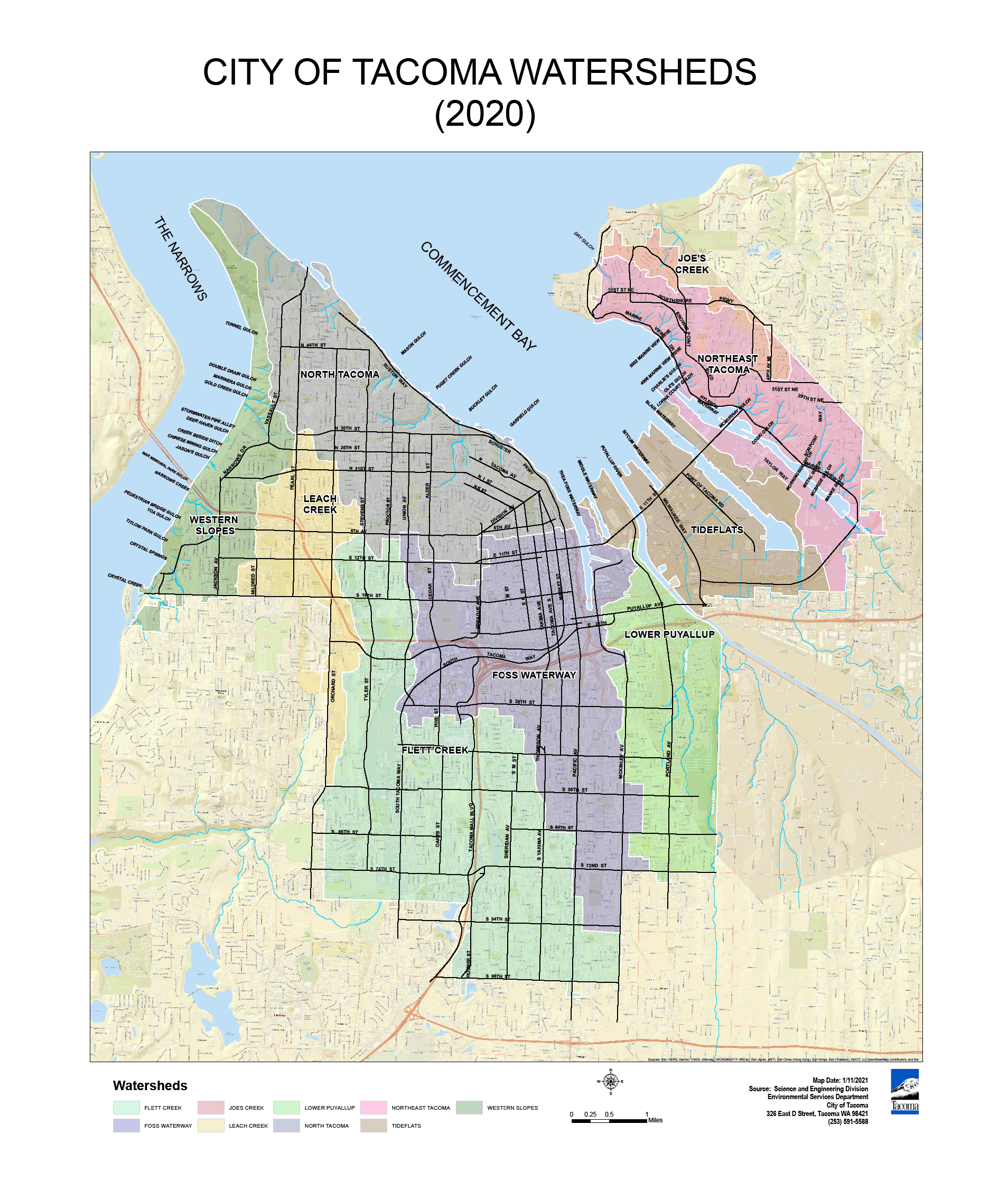
Figure P - 1: City of Tacoma Watersheds
The Flett Creek Watershed is approximately 7,100 acres and is located predominately in the South Tacoma and South End Neighborhood Council Districts. Stormwater within this watershed flows through a series of ponds known as the Hosmer System prior to discharging into the Flett Creek Holding Ponds. The Hosmer System consists of the Hosmer Holding Basin, Ward's Lake, and the Gravel Pit. A pump station at the last of the four Flett Creek Holding Basins pumps stormwater to the Old Flett Dairy Wetland that drains into Flett Creek. Flett Creek flows into Chambers Creek, which discharges to the Narrows Passage.
Snake Lake, the Delong Wetland, Wapato Lake, and the South Tacoma Groundwater Protection District are located within the City of Tacoma boundaries of the Flett Creek Watershed.
The Leach Creek Watershed is approximately 1,700 acres and is located predominately in the South Tacoma, West End, and Central Neighborhood Council Districts. Stormwater within this watershed is piped into the Leach Creek Holding Basin which discharges into Leach Creek. In heavy rainfall events, stormwater is pumped from the holding basin to the Thea Foss Waterway to avoid sending high flows to Leach Creek.
China Lake and the South Tacoma Groundwater Protection District are located within the City of Tacoma boundaries of the Leach Creek Watershed.
The Northeast Tacoma Watershed is approximately 2,600 acres and is located in the Northeast Neighborhood Council Districts. The majority of stormwater is piped directly into Commencement Bay or the Hylebos Waterway.
Dry Gulch, an intermittent stream, is located within the City of Tacoma boundaries of the Northeast Tacoma Watershed.
The Joe's Creek Watershed is approximately 150 acres and is located in the Northeast Neighborhood Council District. Stormwater discharges to the upper reaches of Joe's Creek. Joe's Creek is located in Federal Way. Joe's Creek flows northwest where it discharges into Dumas Bay.
The North Tacoma Watershed is approximately 4,700 acres and is located predominately in the North End and West End Neighborhood Council Districts. Stormwater ultimately discharges to Commencement Bay and the Puget Sound.
Ruston Creek, Asarco Creek, Puget Creek, Mason Creek, and Garfield Gulch are located within the City of Tacoma boundaries of the North Tacoma Watershed.
The Thea Foss Watershed is approximately 5,700 acres and is located predominately in the New Tacoma, Central, and South End Neighborhood Council Districts. Stormwater ultimately discharges to the Thea Foss Waterway.
Portion of the South Tacoma Groundwater Protection District are located within the City of Tacoma boundaries of the Thea Foss Waterway Watershed.
The Tideflats Watershed is approximately 2,100 acres and is located predominately in the New Tacoma Neighborhood Council District. Stormwater ultimately discharges to Commencement Bay in this watershed.
The Sitcum Waterway, the Blair Wateway, the Hylebos Waterway, Hylebos Creek, and Wapato Creek are located within the City of Tacoma boundaries of the Tideflats Watershed.
The Lower Puyallup Watershed is approximately 2,900 acres and is located predominately in the Eastside Neighborhood Council Districts. Stormwater discharges to the Puyallup River in this watershed.
The Puyallup River, Swan Creek, and First Creek are located within the City of Tacoma boundaries of the Tideflats Watershed.
Because of its size, the Puyallup River does not require enhanced treatment even though it is a freshwater designated for aquatic life use. The Puyallup River is a Flow Control Exempt Receiving Waterbodies.
The Western Slopes Watershed is approximately 2,000 acres and is located in the West End Neighborhood Council District. Stormwater discharges to various creeks and gulches and the Narrows.
Gold Creek, Narrows Creek, Crystal Creek, Crystal Springs Creek, Marinera Creek, and Titlow Park Gulch Creek are located within the City of Tacoma boundaries of the Western Slopes Watershed.
South Tacoma Groundwater Protection District
The South Tacoma Groundwater Protection District (STGPD) was created to help protect the South Tacoma Aquifer which is used as a drinking water supply for the City of Tacoma. The STGPD is protected by a program administrated by the Tacoma Pierce County Health Department (TPCHD) and the City of Tacoma. See https://www.tpchd.org/healthy-places/waste-management/business-pollution-prevention/south-tacoma-groundwater-protection-district for additional information including specific permitting information.
Projects that infiltrate pollution generating stormwater in the South Tacoma Groundwater Protection District must provide treatment as specified in the South Tacoma Groundwater Protection District Infiltration Policy Document available at https://www.tpchd.org/healthy-places/waste-management/business-pollution-prevention/south-tacoma-groundwater-protection-district.
Sensitive habitat areas, which include restoration sites and mitigation sites may require additional protection from stormwater. Per Joint Administrative Policy and Procedure Directive No. 2021-02-001, Environmental Services/Site Development Group will determine if additional protection is necessary based upon project scope and discharge location.
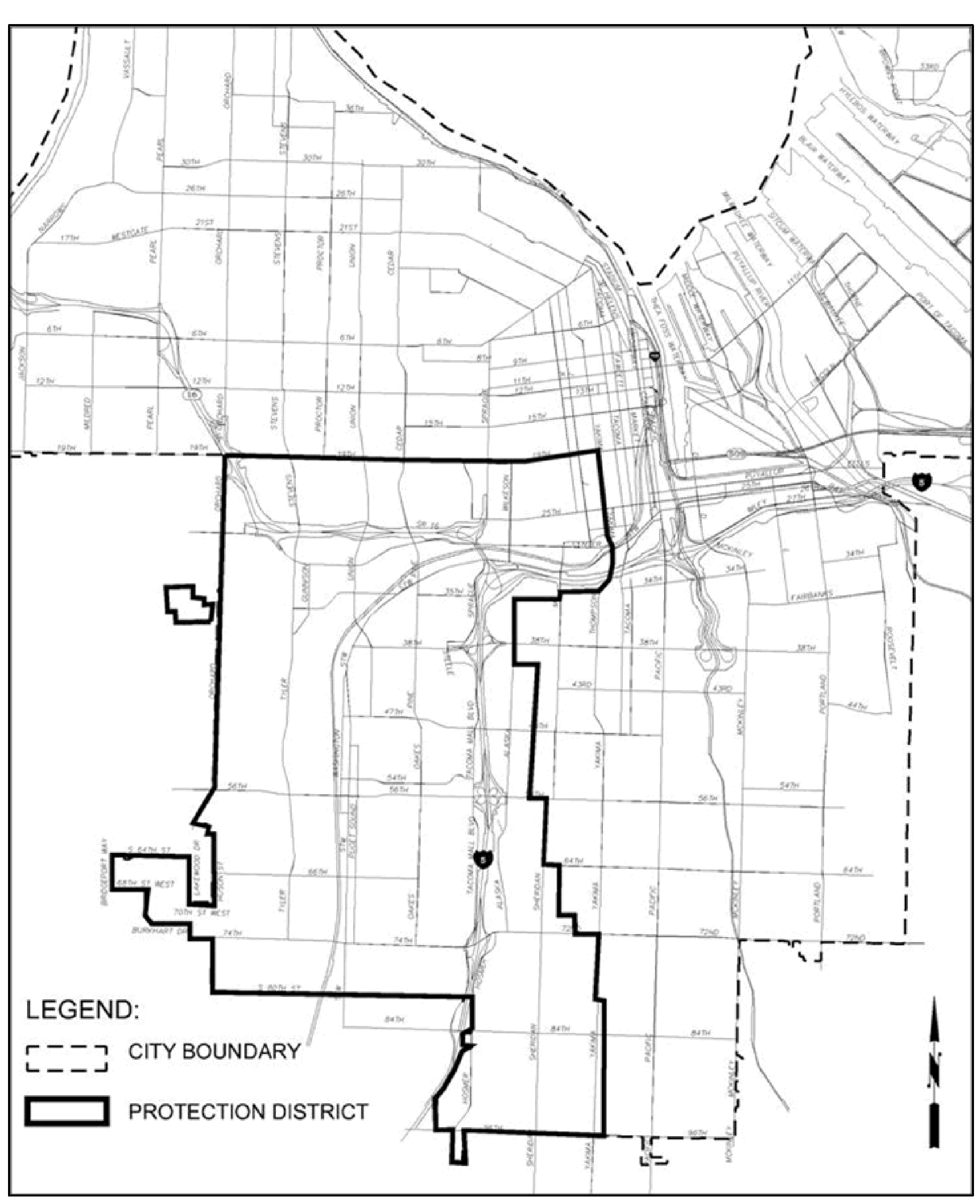
Figure P - 2: South Tacoma Groundwater Protection District (STGPD)
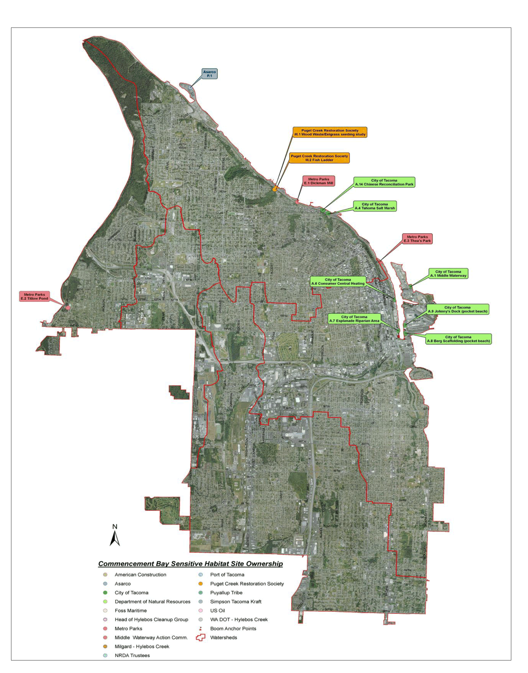
Figure P - 3: NRDA Areas and Sensitive Habitat Areas (West Tacoma Area)
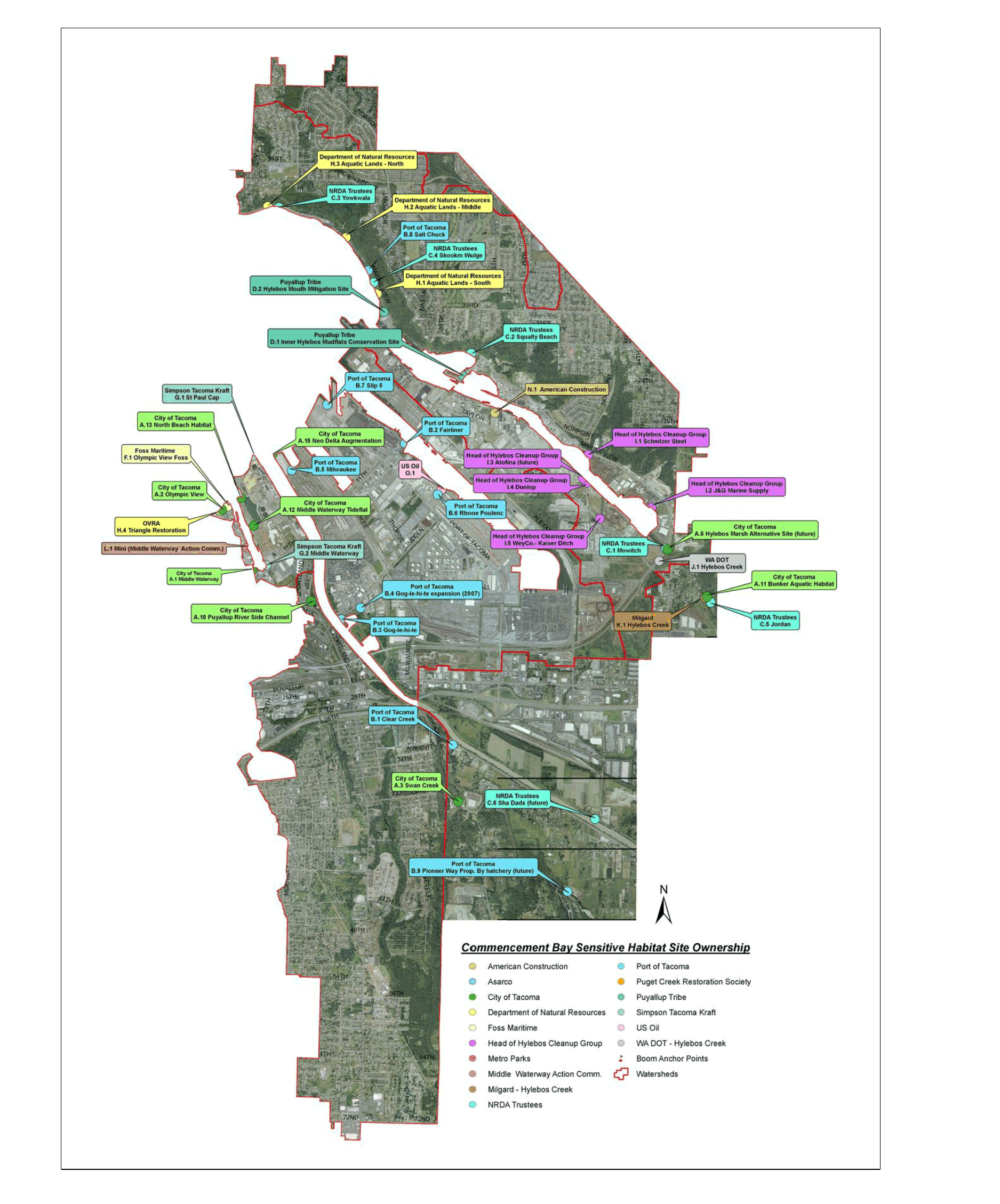
Figure P - 4: NRDA Areas and Sensitive Habitat Areas (East Tacoma Area)
All new development and redevelopment projects within the City of Tacoma, including work both on private property and within the public Right-of-Way, intending to use the Presumptive Approach shall meet the requirements and technical standards of this manual unless specifically exempted by this manual or the Director of Environmental Services. The requirements of this Manual apply to direct and indirect discharges to the City of Tacoma Municipal Separate Stormwater System and all receiving waterbodies (including groundwater) per Tacoma Municipal Code 12.08D.
All projects, whether or not they meet the thresholds for complying with Minimum Requirements, shall:
Comply with all Federal, State and local requirements and the City of Tacoma Municipal Code.
During construction, prevent erosion and discharge of sediment and other pollutants into receiving waters. Volume 3 - Construction Site Stormwater Best Management Practices contains BMPs that can be used during construction to help prevent erosion and discharge of sediment.
Use all known available, and reasonable Source Control BMPs. Volume 6 - Source Control Best Management Practices contains Source Control BMPs.
Size new stormwater conveyance systems per Volume 5 - Stormwater Conveyance Design and Protection of the SWMM.
Analyze, if necessary, existing conveyance systems as required in Volume 5 - Stormwater Conveyance Design and Protection of the SWMM.
Inspect and maintain all portions of their stormwater system. See Volume 4 - Best Management Practices Library for inspection and maintenance information related to stormwater features.
This manual can also be helpful in identifying retrofit options. Compliance with the technical standards is encouraged in retrofit situations.
The Environmental Protection Agency (EPA), created the Clean Water Act to help eliminate the discharge of untreated wastewater into receiving waters thereby helping to ensure those waters are safe for swimming and fishing.
The Clean Water Act made it unlawful to discharge any pollutant from a point source into navigable waters without obtaining a Permit. The NPDES (National Pollutant Discharge Elimination System) Program controls those discharges.
In 1987, the Clean Water Act was amended to include stormwater discharges from MS4s (Municipal Separate Stormwater Systems).
In 1990, Phase I regulations went into effect to allow discharges from MS4s.
In 1995, the Washington State Department of Ecology issued the first NPDES Phase I Municipal Stormwater Permit authorizing jurisdictions to discharge stormwater into receiving waterbodies.
The City of Tacoma is a Phase I Permittee. This means that the City is required to obtain an NPDES Phase I Permit from the Washington State Department of Ecology in order to lawfully discharge stormwater into receiving waters. The Phase I Permit contains the regulations that the City must follow in order to discharge stormwater into receiving waters.
Relationship to Phase I Permit
The most recent National Pollutant Discharge Elimination System (NPDES) Phase I Municipal Stormwater Permit (NPDES Permit) became effective August 1, 2019. Section S5.C.5 of the NPDES Permit requires municipalities to “include a program to prevent and control the impacts of runoff from new development, redevelopment, and construction activities.” This manual is designed to be equivalent to Ecology’s 2019 Stormwater Management Manual for Western Washington in order to meet the NPDES Permit requirement. The Manual has been adopted by City Council Ordinance. The Manual is effective on July 1, 2021.
There are two approaches that a project proponent may use to document the technical basis for their stormwater BMP designs: the Presumptive Approach and the Demonstrative Approach. Both approaches are based on using best available science and result from existing Federal and State laws that require stormwater treatment systems to be properly designed, constructed, maintained, and operated to:
Prevent pollution of state waters and protect water quality, including compliance with State Water Quality Standards.
Satisfy State requirements for All Know Available and Reasonable methods of prevention, control and Treatment (AKART) to prevent and control pollution of waters of the State.
Satisfy the Federal technology-based treatment requirements under 40 CFR 125.3.
Project proponents that choose to follow the design standards for BMPs contained in this manual are presumed to have satisfied State and Federal Requirement and do not need to provide additional technical justification beyond what is required in a Stormwater Site Plan.
Using the Demonstrative Approach, project proponents do not have to follow the design standards within this Manual. The project proponent must demonstrate that the project will not adversely impact water quality by collecting and providing appropriate supporting data to show that the alternative approach is protective of water quality and satisfies State and Federal water quality laws. The timeline and expectations for providing technical justification of stormwater management practices will depend on the complexity of the individual project and the nature of the receiving environment. The Demonstrative Approach will require monitoring, data collection, and analysis to substantiate the use of an alternate BMP or design.
Manual Corrections and Updates
Minor revisions to the manual may occur on an ongoing basis. It is the applicant’s responsibility to verify the requirements when developing stormwater mitigation plans. As needs are identified, additional policies shall be developed and posted to the City website at: www.cityoftacoma.org/stormwatermanual
Related Regulations, Programs, and Documents
Department of Ecology’s Stormwater Management Manual
This manual was modeled after the Stormwater Management Manual for Western Washington, published by the Department of Ecology in July 2019. Ecology’s stormwater manual was originally developed in response to a directive of the Puget Sound Water Quality Management Plan (PSWQA 1987 et seq.). The Puget Sound Water Quality Authority (since replaced by the Puget Sound Partnership) recognized the need for overall guidance for stormwater quality improvement. It incorporated requirements in its plan to implement a cohesive, integrated stormwater management approach through the development and implementation of programs by local jurisdictions, and the development of rules, permits and guidance by Ecology.
The Puget Sound Water Quality Management Plan included a stormwater element (SW-2.1) requiring Ecology to develop a stormwater technical manual for use by local jurisdictions. Ecology’s original stormwater manual (the Stormwater Management Manual for the Puget Sound Basin, published in 1992) was developed to meet this requirement.
This Manual is designed to be equivalent to Ecology's 2019 SWMMWW.
Federal, State and Local Regulatory Requirements
The applicant is responsible for identifying and complying with all applicable federal, state, and local regulatory requirements. Projects may have site specific requirements if they are part of a Superfund or cleanup site.
The Office of Regulatory Assistance website is a useful tool for determining additional permitting requirements that may apply to a project: www.ora.wa.gov
The City of Tacoma Permitting website (tacomapermits.org) is a good tool for determining additional regulations that may be posed by other City of Tacoma Departments.
The Washington State Department of Ecology Toxics Cleanup Program website provides information on Washington State cleanup sites: https://ecology.wa.gov/About-us/Get-to-know-us/Our-Programs/Toxics-Cleanup
The EPA Washington Cleanup Site website can be used to determine if a project is located in or discharges to a Superfund Site: https://www.epa.gov/superfund/search-superfund-sites-where-you-live
There are sites in the City of Tacoma covered under separate Industrial Stormwater General Permits, Construction Stormwater General Permits, Sand and Gravel General Permits, or separate State issued Discharge Permits. Development at these sites may be required to comply with the Minimum Requirements and design standards in this manual. Environmental Services/ Site Development Group reserves the right to determine which requirements apply to a given project.
Certain projects are exempt from obtaining permits from local jurisdictions. These sites may still be required to comply with the Minimum Requirements and design standards in this manual. Projects exempt from permitting may require stormwater mitigation review and approval from the City of Tacoma before discharging stormwater to the City of Tacoma Municipal Separate Storm Sewer System (MS4).
Within the City of Tacoma limits, the Port of Tacoma, Metropolitan Park District of Tacoma, and Tacoma Community College are considered Secondary Permittees. Each permittee is responsible for the MS4 they own or operate. Environmental Services/Site Development Group will review all projects within the City of Tacoma.
Underground Injection Control (UIC) Program
The Washington State Department of Ecology manages the UIC Program which regulated UIS wells. This manual contains several CMPs designed to infiltrate stormwater. These BMPs may be considered UIC wells and therefore must comply with all UIC program requirements. Some examples of UIC wells are drywells, infiltration facilities containing perforated pipe that distributes the water, and underground structures that temporarily store water in the subsurface before infiltration. Visit https://ecology.wa.gov/Regulations-Permits/Guidance-technical-assistance/Underground-injection-control-program for information about UIC wells.