1.4.8 Minimum Requirement 8 - Wetlands Protection
Wetlands are regulated by the City of Tacoma through this requirement and the Ctritical Areas Preservation Ordinance, Tacoma Municipal Code 13.11. For more information about wetlands, wetland permits and development close to wetlands, please see https://www.tacomapermits.org/critical-area-permitting
When assessing a project against the following thresholds, only consider those hard and pervious surfaces that are subject to this Minimum Requirement as determined in Applicability of the Minimum Requirements.
Stormwater discharges to wetlands may require a Critical Area Verification, Minor Development Permit, and/or Development Permit as detailed under the City’s Critical Areas Preservation Ordinance (TMC 13.11).
The requirements below are in addition to requirements given in TMC 13.11 and apply only to projects whose stormwater discharges into a wetland, either directly or indirectly through a conveyance system.
When Minimum Requirement #7 is also required, an attempt must be made to meet both Minimum Requirements. If it is not possible to meet both requirements, then the requirement to maintain the hydroperiod of the wetland (meeting Minimum Requirement #8) becomes the overriding concern and documentation must be provided detailing why both requirements could not be met.
1.4.8.2 Thresholds and Requirements
TDAs within projects that meet the thresholds for Minimum Requirement #8 and discharge stormwater directly or indirectly to a wetland must provide Wetlands Protection. See Figure 1 - 7: Determining Required Wetland Protection Levels to determine which Level of Wetland Protection applies to a project.
1.4.8.2.1 Wetlands Protection Thresholds
The Level of Wetlands Protection is based upon:
The Wetland Category into which the TDA discharges,
Whether or not the TDA triggered Minimum Requirement 7 - Flow Control,
Whether or not the wetland is a depressional or impounded wetland,
Whether or not the project proponent has legal access to the wetland,
Whether or not the wetland provides habitat for rare, endangered, threatened, and/or sensitive species, and
Whether or not there is a presence of a breeding population of native amphibians.
1.4.8.2.2 Determining Required Levels of Protection
Use Figure 1 - 7: Determining Required Wetland Protection Levels to determine the required level of protection specific to the project.
General Protection includes general practices that benefit wetlands of all types.
Protection from Pollutants includes measures to protect the wetland from pollutants in stormwater runoff.
Wetland Hydroperiod Protection
Wetland Hydroperiod Protection includes measures to avoid excessive hydrologic alteration of existing wetlands from development. There are two methods within Wetland Hydroperiod Protection:
Method 1: Monitoring and Wetland Stage: This method requires data collection specific to the wetland, as well as continuous simulation modeling to demonstrate that the proposed project will not negatively alter the wetland hydrology.
Method 2: Site Discharge Modeling: This method requires continuous simulation modeling of the runoff from the TDA to demonstrate that the changes in total discharge volume to the wetland will remain similar to the predevelopment condition.
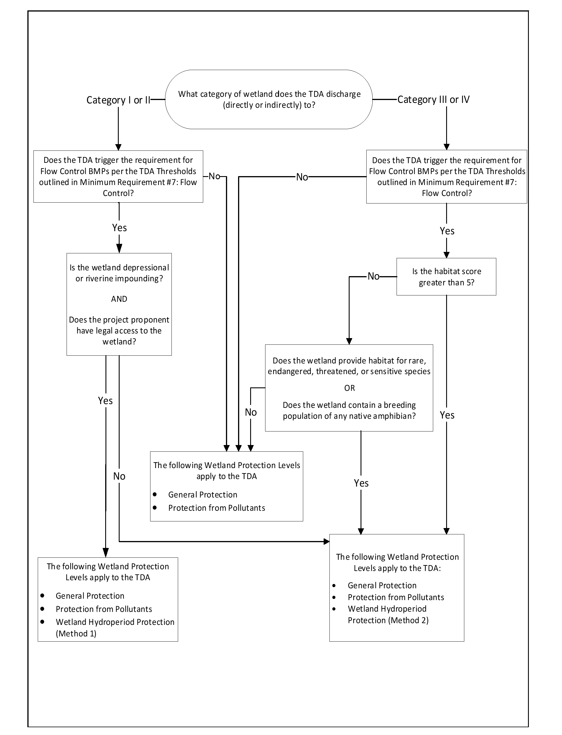
Figure 1 - 7: Determining Required Wetland Protection Levels
1.4.8.2.2.1 Wetland Delineation Report
In order to assess the impacts and risks to wetlands and to determine the required level of protection, a wetland delineation report is required.
Be prepared by a Wetland Specialist (as defined by TMC 13.01.110)
Define the size, boundary, and characteristics of the proposed project site, wetland contributing basin, wetland boundary and its buffers.
Define wetland type, wetland category, and wetland habitat score following the Washington State Department of Ecology "Washington State Wetland Rating System for Western Washington: 2014 Update (Hruby, 2014)".
Note presence of rare, endangered, threatened, or sensitive species.
Note presence of breeding populations of native amphibian species.
Include wetland field monitoring data (if necessary) - See Wetland Hydroperiod Data Collection and Evaluation Procedures
All wetlands (Categories I, II, III and IV) must receive the following general protection:
Consult regulations issued under federal and state laws that regulate the discharge of pollutants to surface waters, including the Construction Stormwater General NPDES Permit.
Maintain the wetland buffer required by local and/or state regulations.
Retain areas of native vegetation connecting the wetland and its buffer with nearby wetlands and other contiguous areas of native vegetation. It is recommended to retain all vegetation connecting wetlands and buffers. If the vegetation is an invasive species or non-desirable, non-native species, it is further recommended to enhance with native vegetation.
Avoid compaction of soil and introduction of invasive plant or animal species in the wetland and its buffer.
Take measures to avoid general physical impacts (e.g., littering and vegetation destruction). Examples are protecting existing buffer zones; discouraging access, especially by vehicles, by planting outside the wetland, and encouragement of stewardship and signage by landowners.
Any stormwater management practices, such as Stormwater Treatment or Flow Control BMP implementation, must be done outside of the wetland buffer boundary, except as allowed by the conditions of a Wetland Development Permit. See tacomapermits.org for additional information of Wetland Development Permits.
Discharge from a BMP or project site should be dispersed using a method to diffuse the flow before entering the wetland buffer. If allowed by the Critical Area Preservation Ordinance, portions or all of the dispersion flowpath may be located within the wetland buffer.
Consider fences to restrict human access, but make sure fences do not interfere with wildlife movement. Fences should be used when wildlife passage is not a major issue and the potential for intrusive impacts is high. When wildlife movement and intrusion are both issues, the circumstances will have to be weighed to make a decision about fencing. Check with the local and/or state agencies to determine if fencing would be allowed.
1.4.8.3.2 Protection from Pollutants
All wetlands (Categories I, II, III and IV) must receive the following protection from pollutants:
Provide Construction Stormwater BMPs per Volume 3 - Construction Site Stormwater Best Management Practices to prevent sediment and other pollutants from entering the wetland.
Provide Source Control BMPs per Volume 6.
Provide On-Site Stormwater Management and use site appropriate development principles, which include LID principles, as much as practicable for the project site, per Volume 4 - Best Management Practices Library and Volume 2 - Documentation. Site-appropriate development principles and practices will help meet other wetland hydroperiod protection criteria and provide additional habitat.
Provide Stormwater Treatment BMPs per Volume 4 to treat stormwater prior to entering the wetland and its buffer.
Note: If the thresholds for Minimum Requirement 6 - Stormwater Treatment are not met for a TDA, then it is not required to provide Stormwater Treatment BMPs for that TDA to comply with Wetlands Protection.
If the wetland is a special characteristic wetland (such as mature or old growth forest wetlands, bogs, estuarine wetlands, wetlands of high conservation value, coastal lagoons, and interdunal wetlands), implement Stormwater Treatment BMPs with the most advanced ability to control nutrient loads. Consider using Stormwater Treatment BMPs with infiltration and active biological filtration.
1.4.8.3.3 Wetland Hydroperiod Protection
Protection of many wetland functions and values depends on maintaining the existing wetland’s hydroperiod. This means maintaining the annual fluctuations in water depth and its timing as closely as possible. If a project triggers the requirements for Flow Control per Minimum Requirement #7, the project must apply the following Wetland Hydroperiod Protection.
The Wetland Hydroperiod Protection is separated into two methods (Methods 1 and 2) that are dependent on the wetland category, and whether the project proponent has legal access to the wetland.
Method 1 requires a minimum one year of monitoring followed by continuous simulation modeling of the wetland stage (called Method 1). Method 1 shall be applied to the wetlands listed below.
Category I or II depressional or riverine impounding (including special characteristics Category I or II) wetlands that the project proponent owns, or the project proponent has legal access to – for purposes of conducting monitoring in the wetland.
Method 1 takes into account wetland specific information and field data, therefore, it allows more detailed evaluation of effects of stormwater on wetland functions. In cases where the project proponent neither owns nor has legal access to the Category I or II wetlands receiving stormwater from a proposed project, Method 2 shall be used.
Method 2 uses a site discharge volume model to evaluate hydrologic changes in a wetland, with no additional wetland monitoring requirement. Method 2 shall be applied to the wetlands listed below.
Category I or II wetlands that are off-site or the project proponent doesn’t have legal access to conduct monitoring in the wetland,
Category I or II riverine, slope or lake-fringe wetlands,
Category III and IV wetlands with habitat score greater than 5,
Category III or IV interdunal special characteristic wetlands,
Category III and IV wetlands that provide habitat for rare, threatened, endangered or sensitive species,
Category III and IV wetlands that contain a breeding population of any native amphibian species.
If the wetland has permanent or seasonal ponding or inundation, assume that it has a breeding population of native amphibians.
For seasonal ponding, if the wetland has surface ponding after May 1 of a normal water year or drier, assume that it has a breeding population of native amphibians.
See the Wetland Rating System for guidance on identifying field indicators.
Recent aerial images of surface water in the wetland during normal water year or drier year can also indicate presence of permanent or seasonal ponding.
1.4.8.3.3.1 Method 1: 1-Year Wetland Monitoring and Wetland Stage Modeling
Method 1 criteria and analysis is based on the presumption that a wetland has limited water level fluctuation and water holding capacity. The risk to the wetland will be minimal if the frequency and duration of water level fluctuation (WLF) in the wetland and the WLF timing post project remain as similar to pre-project levels as possible. Therefore, the criteria sets limits on the frequency and duration of stage excursions (greater WLF than the pre-project level), as well as on overall WLF after development. The criteria were developed based on studies in Wetlands and Urbanization, Implications for the Future (Azous and Horner, 1997).
One water year of field monitoring will characterize the existing WLF and water holding capacity of the wetland, and it will be used to calculate the allowable WLF by the proposed development.
A hydrologic assessment to measure or estimate elements of the hydroperiod under pre-project and post-project conditions should be performed with the aid of a qualified scientist or wetland specialist.
The project proponent must meet the following six Method 1 criteria in order to comply with the Wetland Hydroperiod Protection requirements.
Criteria 1. Mean Monthly WLF Limit
If the pre-project (monitored) mean monthly WLF for a given calendar month is less than 15cm (0.49ft, 5.91inch), the post-project mean WLF of the wetland for that calendar month may increase to no more than 20 cm (0.66ft, 7.87inch).
If the pre-project (monitored) mean monthly WLF for a given calendar month is greater than or equal to 15 cm (0.49ft, 5.91inch), the post-project mean monthly WLF of the wetland for that calendar month may increase by up to, but no more than, 5 cm (0.16ft, 1.97inch).
Without one year of monitoring data, assume the pre-project mean monthly WLF for any month is greater than or equal to 15 cm (0.49ft, 5.91inch), and the post-project mean monthly WLF of the wetland for that calendar month may increase by up to, but no more than, 5 cm (0.16ft, 1.97inch).
Criteria 2. Mean Annual WLF Limit
If the pre-project (monitored) mean annual WLF is less than 15cm (0.49ft), the post-project mean annual WLF of the wetland may increase to no more than 20 cm (0.66ft, 7.87inch).
If the pre-project (monitored) mean annual WLF is greater than or equal to 15 cm (0.49ft, 5.91inch), the post-project mean annual WLF of the wetland may increase by up to, but no more than, 5 cm (0.16ft, 1.97inch)
Without one year of monitoring data, assume the pre-project mean annual WLF is greater than or equal to 15 cm (0.49ft, 5.91inch), and the post-project mean annual WLF of the wetland may increase by up to, but no more than, 5 cm (0.16ft, 1.97inch)
Criteria 3. Frequency of Stage Excursions
The frequency of stage excursions of 15 cm (0.49ft, 5.91inch) above or below the pre-project stage must not exceed an annual average of six.
Criteria 4. Durations of Stage Excursions
The duration of stage excursions of 15 cm (0.49ft, 5.91inch) above or below the pre-project stage must not exceed 3 days per excursion.
For a Wetland that Provides Habitat for Native Amphibians: The stage excursions above or below the pre-project stage must not exceed 8 cm (0.26ft, 3.15inch) for more than 1 day in any 30-day period between January 1 and May 31. The hydroperiod limits characterize wetlands inhabited by breeding native amphibians and apply to breeding zones during the period of January 1 through May 31. If these limits are exceeded, then amphibian breeding success is likely to decline.
For a Peat Wetland: The duration of stage excursions in the post-project scenario cannot be above the pre-project stage for more than 1 day in any year, and applies to all zones over the entire year. If this limit is exceeded, then characteristic bog or fen wetland vegetation is likely to decline.
Criteria 5. Total Dry Period Change
The total dry period (when pools dry down to the soil surface everywhere in the wetland) must not increase or decrease by more than two weeks in any year between the pre-project and post-project scenarios.
Criteria 6. Perennial to Ephemeral or Seasonal Avoidance
Alterations to watershed and wetland hydrology that may cause perennial wetlands to become ephemeral or seasonal post-project must be avoided.
If modeled wetland stage indicates that the wetland is perennial, the dry period at the post-project scenario should not exceed 1 day in any year.
Additional guidance, as well as an excel template to assist with the calculations to verify compliance with Method 1 is provided in Wetland Hydroperiod Data Collection and Evaluation Procedures.
1.4.8.3.3.1.1 Wetland Hydroperiod Data Collection and Evaluation Procedures for Method 1
Field Monitoring and Data Collection
Field monitoring data of the wetland must be collected to determine the existing pre-project hydroperiod, which will then be compared to model outputs to verify compliance with the Hydroperiod Protection Criteria. Without one year of hydroperiod monitoring, the minimum allowable WLF change can be used (see Criteria for Method 1 in Wetland Hydroperiod Protection and Steps to Verify Compliance with the Method 1 Hydroperiod Protection Criteria below).
An Ecology approved continuous simulation model will be needed for data analysis. Relevant historic monitoring information can also inform the pre-project condition of the wetland. The following lists describe the minimum required wetland specific information in order to implement the Method 1 Wetland Hydroperiod Protection guidance.
1. Contour Data or Water Storage Capacity
Bathymetry, or wetland contours, is indicative of the water storage capacity of the wetland that will be used in the model simulation.
If possible, the bathymetry of the wetland should be surveyed. LIDAR data or GIS analysis may also be used to provide approximate wetland contours.
In the absence of bathymetry data, approximate the bathymetry using the permanent ponding area and assume that the storage will occur on top of that area. This resulting storage area will be lower than the actual area, providing a more protective model.
Collect at least one year of water levels (instantaneous water stage and crest stage) using a crest stage gage or continuous water level loggers in the wetland. Water levels should be collected at least monthly over a year.
Average base stage = (Instantaneous stage at the beginning of interval + Instantaneous stage at the end of interval)/2
The goal of this monitoring is to construct a relationship in the model to simulate how flows will be released from the wetland for each given stage. A simplified monitoring approach may be appropriate for a simple wetland flow regime. For instance, where a well-defined outlet controls the outflows from a wetland, instantaneous monitoring of the outflow for the typical range of flows may be sufficient. In this simple case, a velocity and cross-section and stage monitoring at the outlet can be sufficient to create the relationship for the model. These measurements may be performed in conjunction with the hydroperiod monitoring described above. Additional field visits timed with precipitation or dry periods may be necessary to ensure that the outflow relationship covers the range of modeled flows.
Ecology acknowledges that it can be challenging to determine the location(s) of flows to and from wetlands. In some cases, there will be a clear channel that is the source of the inflows and outflows, while in others, the water may disperse over a wide area. An alternative would be to gather nearly continuous (every 15 minute) rainfall data along with wetland stage data (hydroperiod monitoring) and adjust the storage and discharge rate within the model using these data. If the flow data or estimation in the model are not available, assume there is no surface outflow for the wetland (closed depression).
Chapter 8 of Wetlands and Urbanization, Implications for the Future (Azous and Horner, 1997) indicates that a complete wetland water balance includes precipitation, evapotranspiration, surface inflow, surface outflow, groundwater exchange, and change in wetland storage using a tipping-bucket gage and continuous flow measurements. The wetland assessment as part of this Method 1 needs to consider the more protective approach to develop that relationship. A scientist (e.g. wetland scientist or hydrologist) may determine that the groundwater flow is a significant characteristic of the outflow of the system. In this case the project proponent may need to determine the groundwater regime of the system.
Model Construction and Simulation for Method 1
The project proponent should develop a stage-storage-discharge (SSD) table that represents the volume of water that ponds in the wetland and the flowrate of water that discharges from the wetland at a given stage.
An Ecology approved continuous simulation model using 15-minute timesteps shall be utilized for wetland hydroperiod modeling for the pre-project and post-project simulation as described below.
Having a reliable SSD table that represents the wetland is essential to evaluate the effects of development in the model. Wetland bathymetry and contour data by field measurement or using equations to represent the volume-area-depth relations of wetlands and wetland flow monitoring data are critical to develop the SSD table for the wetland.
In the absence of actual wetland flow monitoring data, it may be possible to develop a SSD table for the wetland by combining the model simulated flows with the field data obtained on the wetland WLF (hydroperiod monitoring) data. This would require an iterative modeling process. The modeling iterations would involve manually changing the discharge rates in the SSD table until the resulting simulated WLF approach WLF from the field monitoring data. The project proponent or modeler shall provide the details of how this was estimated in its hydrologic assessment report.
With an SSD table, the following are necessary for the model simulation to evaluate the discharge of development in the model and determine compliance with the Method 1 Wetland Hydroperiod Protection criteria.
Pre-project condition land uses and associated acreage for the entire contributing area that drains to the wetland.
Post-project condition land uses and associated acreage for the entire contributing area that drains to the wetland.
Percentage of developing project area compared to total acreage of contributing area that drains to the wetland.
Identify existing impervious and pervious surfaces that discharge to the wetland and use the model elements to represent the land use and associated acreage for all hydrologically contributing areas to the wetland.
Add the wetland buffer using the lateral flow soil basin, or include it as part of the contributing area land use.
Connect the runoff from the contributing basin(s) including interflow and groundwater to the SSD table that represents the wetland.
Set the outflow of the wetland as the Point of Compliance (POC).
Identify anticipated impervious and pervious surfaces that discharge to the wetland and use the model elements to represent the land use and associated acreage for all hydrologically contributing areas to the wetland.
Identify any Flow Control BMPs in the contributing area draining to the wetland and use the appropriate model elements to represent these facilities.
Add the wetland buffer using the lateral flow soil basin, or include it as part of the contributing area land use.
Connect the runoff from the contributing basin(s) (including the buffer) including interflow and groundwater to the same SSD table that was used in the pre-project scenario.
Connect flows from any Flow Control BMP elements through the downstream element(s) to SSD table that represents the wetland.
Connect any infiltration from Flow Control BMP elements to groundwater of SSD table (if applicable).
Set the outflow of the wetland as the POC.
The order of the steps above depends on the type of elements and their intended function and could change to be more representative of the contributing flow pathways to the wetland.
Once the model simulations are done for post and pre-project scenarios, export the SSD table stage data for the full period of record: daily, monthly and yearly average, and Max and Min stage.
These model outputs, together with monitored WLF, are to be used to verify compliance with the Method 1 Hydroperiod Protection Criteria in Wetland Hydroperiod Protection.
Steps to Verify Compliance with the Method 1 Hydroperiod Protection Criteria
An excel template has been developed by the Washington State Department of Ecology to assist with the calculation steps. The template can be downloaded from the interactive online version of the Washington State Department of Ecology Stormwater Management for Western Washington.
1) Calculate the Existing WLF of Wetland using Monitored Water Levels
Using the measurements of crest and instantaneous stage during a series of time intervals over a year, calculate water level fluctuation (WLF) between measurements.
Calculate mean annual and mean monthly WLF as the arithmetic averages of a year and each month for which data are available.
Water level fluctuation (WLF) = Crest stage - Average base stage
2) Estimate the WLF by Continuous Simulation of Stages in the Model
Using modeled daily, monthly and yearly stages (average, max and min) for the full period of record, calculate daily, monthly or annual WLF as follows:
WLF = Max stage - average stage
3) Calculate Allowable WLF change
Allowable WLF change by the proposed project is determined by two factors: Monitored WLF of the wetland, and the size of the proposed project relative to the wetland’s contributing basin area.
Allowable WLF change for the proposed project is calculated as follows:
If monitored WLF is less than 15 cm (0.49 ft, 5.91 inch),
Allowable WLF change for the wetland (A) = 20 cm (0.66 ft, 7.87 inch) – monitored WLF
Allowable WLF change for the proposed project = A / percentage of development by proposed project in the contributing basin area.
If monitored WLF for a given calendar month is greater than or equal to 15 cm (0.49 ft, 5.91 inch),
Allowable WLF of the wetland (A) for that calendar month may increase by up to, but no more than, 5 cm (0.1 6ft, 1.97 inch).
Allowable WLF change for the proposed project = 5 cm / percentage of development by proposed project in the contributing basin area.
For example, if the project develops 10 acres of a 100 acre basin (10 %), the project can cause no more than 10 % of total allowable WLF change in the wetland. If the total allowable WLF change for the wetland is 10 cm (0.32 ft, 3.94 inch), the allowable WLF change for the proposed site is 1.0 cm (0.032 ft, 0.394 inch).
4) Verify Compliance with the Criteria
Compare each modeled daily, monthly or annual WLF with the calculated allowable WLF (factored by percentage of development by proposed project in the contributing basin area). If any of the modeled WLF difference between pre-project and post-project scenarios exceeds the calculated allowable WLF change for the proposed project, it means the proposed project does not comply with Method 1 Wetland Hydroperiod Protection.
For criteria about durations and frequencies, assess individual modeled stage outputs to verify compliance.
1.4.8.3.3.2 Method 2: Site Discharge Modeling
An alternative way to predict the risk to the wetland hydroperiod from stormwater discharges is to assess the changes in total volume of flows into a wetland that result from the development project. The size of the wetland and its capacity are not known or needed to utilize Method 2. The risk to wetland functions will be assumed to increase as the total discharge volumes from the site into the wetland diverge from the pre-project conditions. The risk will be decreased if the divergence is smaller.
As stormwater generated at the project site passes through the wetland buffer, total discharge volumes from the site to the wetland are to be calculated at the outflow of the wetland buffer. The existing or required length and area of wetland buffer per local and/or state regulations around the wetland should be included as an element in the model under both pre-project (existing) and post-project scenarios.
The project proponent must ensure they are meeting both of the following Method 2 criteria in order to comply with Wetland Hydroperiod Protection.
Criteria 1. Mean Daily Total Discharge Volumes from the Site
Total volume of water into a wetland on daily basis should not be more than 20% higher or lower than the pre-project volumes.
Calculate the average of the total discharge volumes from the site for each day over the period of precipitation record in the approved model for pre- and post-project scenarios. There will be 365 (366 for a leap year) average daily values for the pre-project scenario and 365 (366 for a leap year) for the post-project. No day can exceed 20% change in volume.
Criteria 2. Mean Monthly Total Discharge Volumes from the Site
Total volume of water into a wetland on a monthly basis should not be more than 15% higher or lower than the pre-project volumes.
Calculate the average of the monthly total discharge volumes from the site for each calendar month over the period of precipitation record in the approved model for pre- and post-project scenarios. No month can exceed 15% change in volume.
The guidance for implementing Method 2 and assessing the criteria above in the respective model is provided in Wetland Hydroperiod Data Collection and Evaluation Procedure for Method 2.
Method 2 may not result in complete protection of wetland functions and values as these criteria are based on risk to the resource rather than an actual understanding of the impacts. When applicable, Ecology recommends application of the Wetland Hydroperiod Protection with wetland-specific monitoring as described in Method 1.
1.4.8.3.3.2.1 Wetland Hydroperiod Data Collection and Evaluation Procedure for Method 2
Model Construction and Simulation
When modeling, include the wetland buffer downstream of the project area as the final element in both the pre-project and post-project scenarios. In the model, also include any flow control BMPs. The point of compliance (POC) should be assigned to capture the total (surface, interflow, and groundwater) volume leaving the wetland buffer for both the pre-project and the post-project scenarios.
An Ecology approved continuous simulation model using 15-minute timesteps shall be utilized for wetland hydroperiod modeling for the pre-project and post-project simulation as described below.
Identify existing impervious and pervious surfaces that discharge to the wetland and use the model elements to represent these land areas.
Identify the wetland buffer area and use the lateral flow soil basin to represent the wetland buffer.
Connect the model elements to the wetland buffer ensuring that impervious land areas are connected to surface flows and that for any other model elements all flows (surface, interflow, and groundwater) are connected.
Set the wetland buffer element as the most downstream element.
Set the POC at the outflow of the wetland buffer element including surface runoff, interflow, and groundwater.
Identify anticipated post-project impervious and pervious surfaces that discharge to the wetland and use the model elements to represent these land areas.
Identify any Flow Control BMPs and use the appropriate the model elements to represent these facilities.
Identify the wetland buffer area and use the lateral flow soil basin to represent the wetland buffer.
Connect the model elements to the wetland buffer ensuring that impervious land areas are connected to surface flows and that for any other model elements all flows (surface, interflow, and groundwater) are connected.
Connect any Flow Control BMP elements to the wetland buffer ensuring that surface flows are connected to surface water and any infiltration is connected to groundwater.
Set the wetland buffer element as the most downstream element.
Set the POC at the outflow of the wetland buffer element including surface runoff, interflow, and groundwater.
Once the model simulations are done for post and pre-project scenarios, verify compliance with the Method 2 Hydroperiod Protection Criteria.
1.4.8.3.3.3 Strategies to meet the Wetland Hydroperiod Protection Criteria
Consider the following strategies to minimize impacts on the wetland hydroperiod and to meet the Wetland Hydroperiod Protection Criteria. The list is in order of preference:
Increasing the retention of natural pervious cover.
Reducing the level of development.
Reducing the total amount of impervious surfaces.
Increasing infiltration using Onsite Stormwater Management BMPs and site appropriate development principles which include LID principles.
Increasing or maintaining larger wetland buffer zones.
Increasing infiltration and/or storage capacity of Flow Control BMPs.
1.4.8.4 Stormwater Treatment and Flow Control Facility Placement
Stormwater treatment and flow control facilities shall not be constructed within a wetland or its buffer unless approved as part of a City of Tacoma Critical Area Verification, Minor Development Permit, and/or Development Permit. If selective runoff bypass is proposed to maintain the hydroperiod, the hydraulic analysis shall consider the impacts of the bypassed flow. Bypassed flow shall comply with Minimum Requirement 6 - Stormwater Treatment and Minimum Requirement 7 - Flow Control as applicable.
Wetlands are extremely important natural resources which provide multiple stormwater benefits, including groundwater recharge, flood control, and stream channel erosion protection. They are easily impacted by development unless careful planning and management are conducted. Wetlands can be severely degraded by stormwater discharges from urban development due to pollutants in the runoff and also due to disruption of natural hydrologic functioning of the wetland system. Changes in water levels and the frequency and duration of inundations are of particular concern. This requirement ensures wetlands are protected.