1.43 BMP C241 - Temporary Sediment Pond
Sediment ponds remove sediment from runoff originating from disturbed areas of the site. Sediment ponds are typically designed to remove sediment no smaller than medium silt (0.02 mm). Consequently, they usually reduce turbidity only slightly.
Prior to leaving a construction site, dirty stormwater must pass through a sediment pond or other appropriate sediment removal best management practice.
Use a sediment pond where the contributing area is 3 acres or more. Ponds must be used in conjunction with erosion control practices to reduce the amount of sediment flowing into the basin.
1.43.3 Design and Installation Specifications
Only install sediment basins on sites where failure of the structure would not result in loss of life, damage to homes or buildings, or interruption of use or service of public roads or utilities. Also, sediment traps and ponds are attractive to children and can be very dangerous. Compliance with local ordinances regarding health and safety must be addressed. If fencing of the pond is required, show the type of fence and its location on the ESC plan.
Structures having a maximum storage capacity at the top of the dam of 10 acre-feet (435,600 cubic feet) or more are subject to the Washington Dam Safety Regulations (Chapter 173-175 WAC).
See Figure 3 - 29: Sediment Pond, Figure 3 - 30: Sediment Pond Cross Section and Figure 3 - 31: Sediment Pond Riser Detail for details.
If permanent detention facilities are part of the project, they may be used for sediment retention. The surface area requirements of the sediment basin must be met. This may require enlarging the permanent basin to comply with the surface area requirements. If a permanent control structure is used, it may be advisable to partially restrict the lower orifice with gravel to increase residence time while still allowing dewatering of the basin.
Use of infiltration facilities for sedimentation basins during construction tends to clog the soils and reduce their capacity to infiltrate. If infiltration facilities are to be used, the sides and bottom of the facility must only be rough excavated to a minimum of 2 feet above final grade. Final grading of the infiltration facility shall occur only when all contributing areas are fully stabilized. The infiltration pretreatment facility should be fully constructed and used with the sedimentation basin to help prevent clogging.
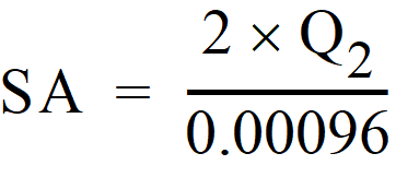
Determine the required surface area at the top of the riser pipe with the equation:
 OR
ORSA = Design surface area, in square feet, of the sediment trap measured at the invert of the weir.
Q2 = Design inflow, in cubic feet per second, is the peak volumetric flowrate from the contributing area calculated using a 10-minute timestep from a Type 1A, 2-year, 24-hour frequency storm using a single even model. A type 1A, 10-year, 24-hour frequency storm (Q10) shall be used in the calculation if the project size, expected timing and duration of construction, or downstream conditions warrant a higher level of protection. If no hydrologic analysis is required, the Rational Method may be used.
Q2 = Design inflow (cfs) is the 2-year return period flowrate, indicated by an Ecology-approved continuous simulation model, using an 15-minute timestep. Use the 10-year return period flowrate (Q10) in the calculation if the project size, expected timing and duration of construction, or downstream conditions warrant a higher level of protection.
See BMP C240 - Sediment Trap for more information on the derivation of the surface area calculation.
The basic geometry of the pond can now be determined using the following design criteria:
Required surface area SA (from the equation above) at top of riser.
Minimum 3.5-foot depth from top of riser to bottom of pond.
Maximum 3H:1V interior side slopes and maximum 2H:1V exterior slopes. The interior slopes can be increased to a maximum of 2H:1V if fencing is provided at or above the maximum water surface.
One foot of freeboard between the top of the riser and the crest of the emergency spillway.
Length-to-width ratio between 3:1 and 6:1.
Sizing of Discharge Mechanisms
The outlet for the basin consists of a combination of principal and emergency spillways. These outlets must pass the peak volumetric flowrate expected from the contributing area for a Type 1A, 100-year, 24-hour frequency storm. If, due to site conditions and basin geometry, a separate emergency spillway is not feasible, the principal spillway must pass the entire peak volumetric flowrate expected from Type 1A, 100-year, 24-hour frequency storm. However, an attempt to provide a separate emergency spillway should always be made. Base the calculations on the site conditions during construction. The flow through the dewatering orifice cannot be utilized when calculating the 100-year storm elevation because of its potential to become clogged; therefore, available spillway storage must begin at the principal spillway riser crest.
The principal spillway designed by the procedures contained in this standard will result in some reduction in the peak volumetric flowrate. However, the riser outlet design will not adequately control flowrates as required to meet Minimum Requirement 7 - Flow Control. The size of the basin, the expected life of the construction project, the anticipated downstream effects, and the anticipated weather conditions during construction should be considered to determine the need of additional discharge control.
Principal Spillway: Determine the required diameter for the principal spillway (riser pipe). The diameter shall be the minimum necessary to pass the peak volumetric flowrate calculated using a 10-minute timestep from a Type 1A, 10-year, 24-hour frequency storm using a single event model for the developed condition or the 10-year return period flowrate, indicated by an Ecology-approved continuous simulation model, using a 15-minute timestep. Use Figure 3 - 32: Riser Inflow Curves to determine this diameter (h = 1-foot).
Note: A permanent control structure may be used instead of a temporary riser.
Emergency Overflow Spillway: Size and design the emergency overflow spillway per A600 - Emergency Overflow Spillway.
Dewatering Orifice: Determine the size of the dewatering orifice(s) (minimum 1-inch diameter) using a modified version of the discharge equation for a vertical orifice and a basic equation for the area of a circular orifice. Determine the required area of the orifice with the following equation:
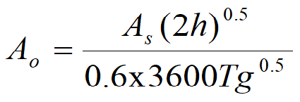
Ao = orifice area (square feet)
As = pond surface area (square feet)
h = head of water above orifice (height of riser in feet)
T = dewatering time (24 hours)
g = acceleration of gravity (32.2 feet per second squared)
Convert the required surface area to the required diameter D of the orifice:
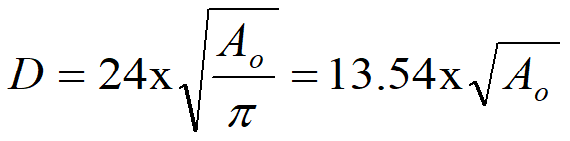
The vertical, perforated tubing connected to the dewatering orifice must be at least 2 inches larger in diameter than the orifice to improve flow characteristics. The size and number of perforations in the tubing shall be large enough so the tubing does not restrict flow. The orifice shall control the flowrate.
Additional Design Specifications
The pond shall be divided into two roughly equal volume cells by a permeable divider that will reduce turbulence while allowing movement of water between cells. The divider shall be at least one-half the height of the riser and a minimum of one foot below the top of the riser. Wire-backed, 2- to 3-foot high, extra strength filter fabric supported by treated 4"x4"s can be used as a divider. If the pond is more than 6 feet deep, a different mechanism must be proposed. A riprap embankment is one acceptable method of separation for deeper ponds. Other designs that satisfy the intent of this provision are allowed as long as the divider is permeable, structurally sound, and designed to prevent erosion under or around the barrier.
To aid in determining sediment depth, prominently mark one-foot intervals on the riser.
If an embankment height of more than 6 feet is proposed, the pond must comply with the criteria contained in Volume 4 regarding dam safety for detention BMPs.
The most common structural failure of sedimentation basins is caused by piping. Piping refers to two phenomena: (1) water seeping through fine-grained soil, eroding the soil grain by grain and forming pipes or tunnels and (2) water under pressure flowing upward through a granular soil with a head of sufficient magnitude to cause soil grains to lose contact and capability for support.
The most critical construction sequences to prevent piping will be:
Tight connections between the riser and barrel and other pipe connections.
Adequate anchoring of the riser.
Proper soil compaction of the embankment and riser footing.
Proper construction of anti-seep devices.
Remove sediment from the pond when it reaches 1–foot in depth.
Repair any damage to the pond embankments or slopes.
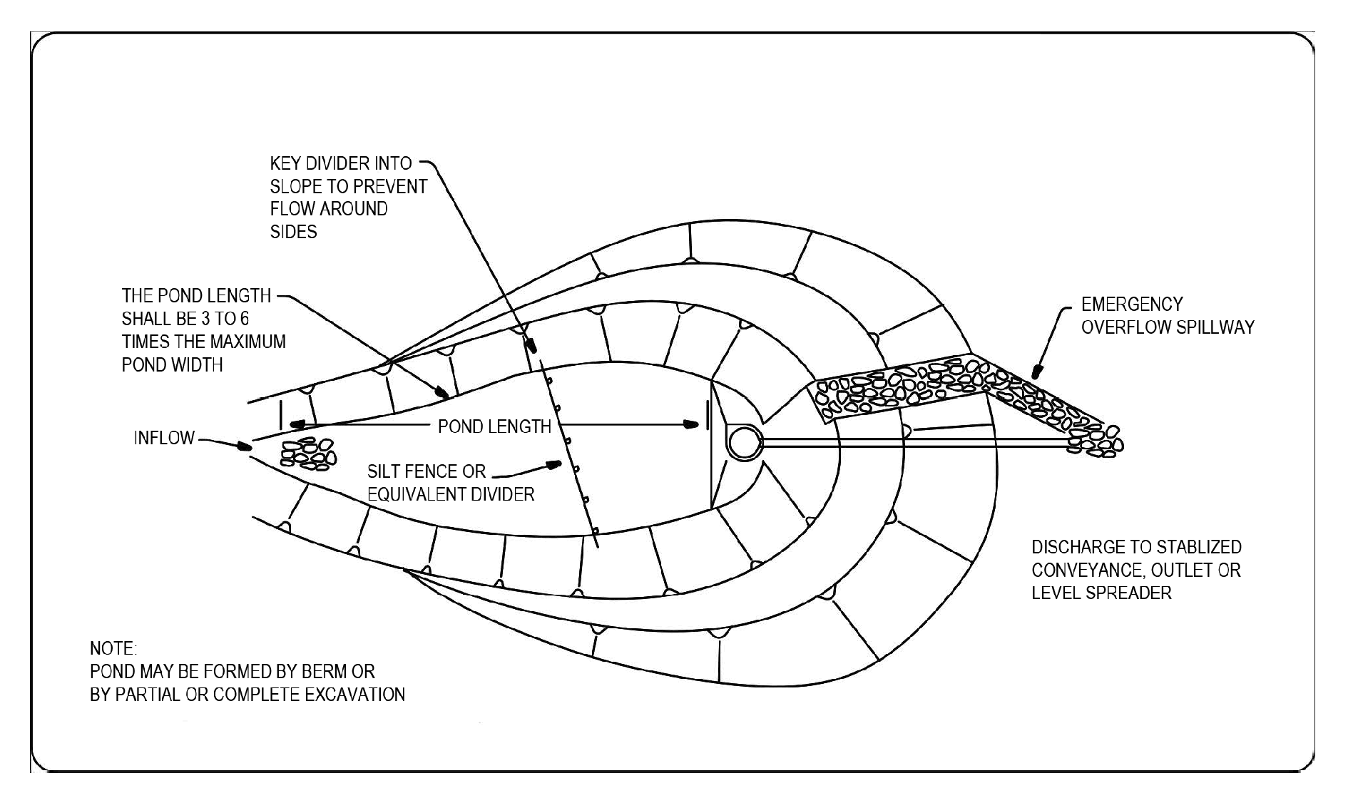
Figure 3 - 29: Sediment Pond
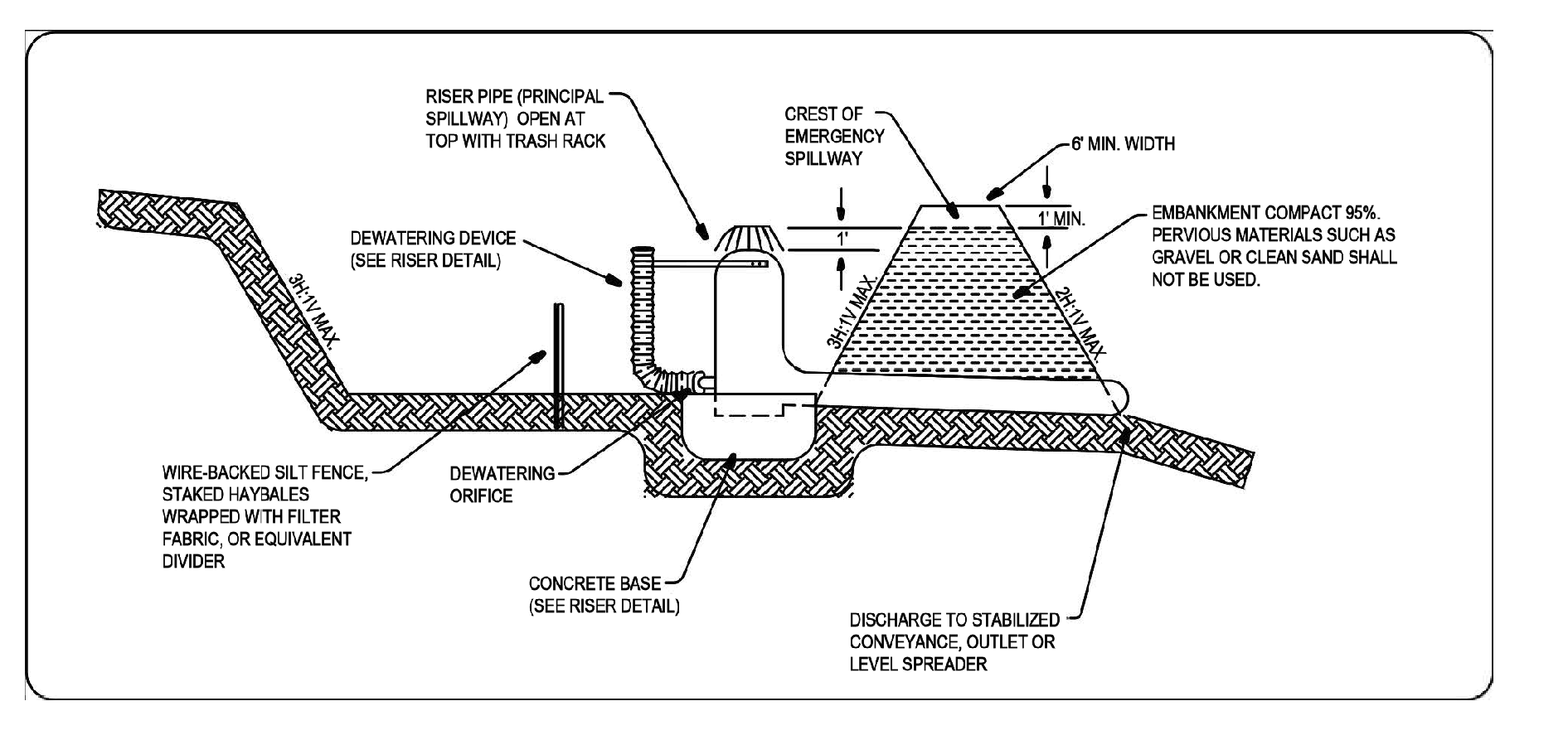
Figure 3 - 30: Sediment Pond Cross Section
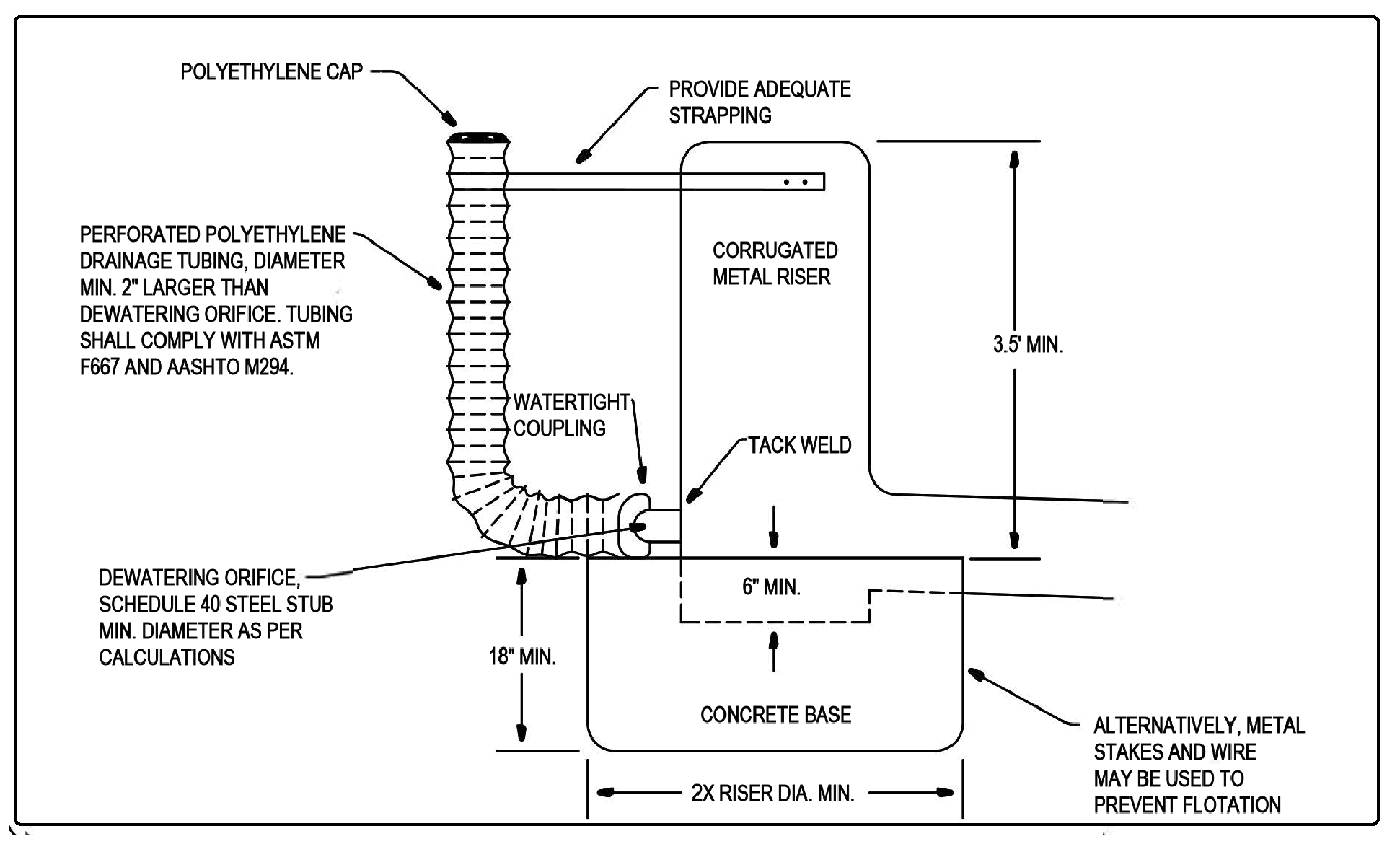
Figure 3 - 31: Sediment Pond Riser Detail
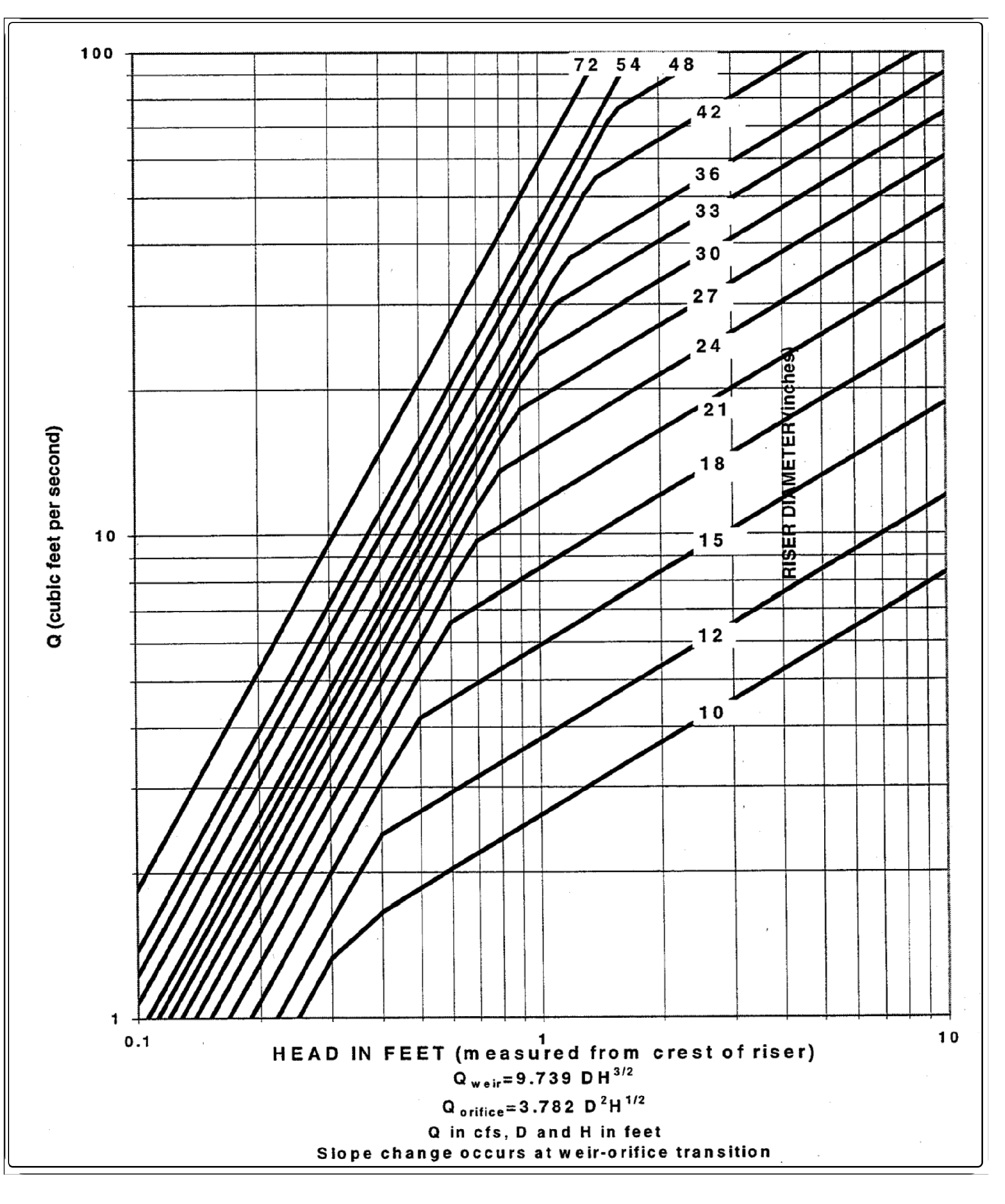
Figure 3 - 32: Riser Inflow Curves