Bioretention areas are shallow landscaped depressions, with a designed soil mix and plants adapted to the local climate and soil moisture conditions that receive stormwater from a contributing area. Bioretention areas can provide effecitive removal of many stormwater pollutants, and reduce stormwater flowrates and volume.
In this manual, bioretention areas are categorized as follows:
Bioretention cells: Shallow depressions with a designed planting soil mix and a variety of plant material, including trees, shrubs, grasses, and/or other herbaceous plants. Bioretention cells may or may not have an underdrain and are not designed as a conveyance system.
Bioretention swales: Incorporate the same design features as bioretention cells; however, bioretention swales are designed as part of a system that can convey stormwater when maximum ponding depth is exceeded. Bioretention swales have relatively gentle side slopes and ponding depths that are typically 6 to 12 inches.
Bioretention planters and planter boxes: Designed soil mix and a variety of plant material including trees, shrubs, grasses, and/or other herbaceous plants within a vertical walled container usually constructed from formed concrete, but could include other materials. Planter boxes are completely impervious and include a bottom (must include an under-drain). Planters have an open bottom and allow infiltration to the subgrade. These designs are often used in ultra-urban settings.
Note: Ecology has approved use of certain patented treatment systems that use specific, high rate media for treatment. Such systems are not considered LID BMPs and are not options for meeting the requirements of Minimum Requirement 5 - Onsite Stormwater Management. The Ecology approval is meant to be used for Minimum Requirement 6 - Stormwater Treatment, where appropriate.
This BMP can be utilized to ensure compliance with Minimum Requirement 5 - Onsite Stormwater Management.
The BMP can be used solely to mitigate for roof surfaces and other hard surfaces if utilizing the List Approach or may be used in combination with other BMPs to satisfy the LID Performance Standard.
Bioretention facilities installed for Minimum Requirement 5 - Onsite Stormwater Management shall only be constructed where infiltration is feasible.
This BMP may also be used to help ensure compliance with Minimum Requirement 6 - Stormwater Treatment, Minimum Requirement 7 - Flow Control, and Minimum Requirement 8 - Wetlands Protection.
Where compliance with Minimum Requirements is not required, where feasible, this BMP is recommended to be used to help protect receiving waterbodies from the effects of stormwater.
11.2.3 Infeasibility Criteria
The following infeasibility criteria describe conditions that make bioretention infeasible when applying The List Approach for compliance with Minimum Requirement 5 - Onsite Stormwater Management.
The infeasibility criteria shall also be used to determine the appropriateness of installing bioretention facilities on a project site. Project proponents may be allowed to install a bioretention facility even if considered infeasible, unless otherwise stated within the specific infeasibility criteria, provided documentation is included that substantiates the design. Documentation may be required by a Washington State Licensed Professional Engineer or other appropriate professional depending upon the project conditions.
Setback distances are measures from the bottom edge of the bioretention soil mix.
A site characterization study must be completed in order to determine if the infeasibility criteria apply and to determine appropriateness of installing a bioretention facility.
The following infeasibility criteria are based on conditions such as topography and distances to predetermined boundaries. Citation of the following do not need site-specific written recommendations from a Washington State Licensed Professional Engineer or Washington State Licensed Professional Geologist though some criteria may require professional services to determine if the infeasibility criteria apply.
Within 10 feet of a building structure.
Within 5 feet of any other structure or property line.
Within 50 feet from the top of any slope greater than 20% and geologically hazardous areas. The bioretention facility may be sited within 50 feet of a slope greater than 20% and/or geologically hazardous area if a geotechnical analysis performed by a Washington State Licensed Professional Engineer or Washington State Licensed Professional Geologist determines that there will be no negative impacts to the slopes and/or geologically hazardous area caused by bioretention facility.
Where land for the bioretention facility is within an area designated as an erosion hazard or landslide hazard.
Within 100 feet of an underground storage tank and connecting underground pipes when the capacity of the tank and pipe system is greater than 1100 gallons.
Within 10 feet of an underground storage tank and connecting underground pipes when the capacity of the tank and pipe system is 1100 gallons or less. (As used in this criteria, an underground storage tank means any tank used to store petroleum products, chemicals, or liquid hazardous wastes of which 10% or more of the storage volume (including volume in the connecting piping system) is beneath the ground surface.)
Within 100 feet of a closed or active landfill.
Within 100 feet of a drinking water well, or a spring used for drinking water supply.
Within 10 feet of small on-site sewage disposal drainfield, including reserve areas, and greywater reuse systems. For setbacks from a “large on-site sewage disposal system”, see WAC Chapter 246-272B.
Where the site cannot be reasonably designed to locate bioretention facilities on slopes less than 8%.
Where they are not compatible with the surrounding stormwater system (e.g., surfaces drain to an existing stormwater system whose elevation precludes proper connection to the bioretention facility).
For properties with known soil or groundwater contamination:
Within 100 feet of an area known to have deep soil contamination;
Where groundwater modeling indicates infiltration will likely increase or change the direction of the migration of pollutants in the groundwater.
Wherever surface soils can be found to be contaminated unless those soils are removed within 10 horizontal feet from the infiltration area;
Any area where these facilities are prohibited by an approved cleanup plan under the state Model Toxics Control Act or Federal Superfund Law, or an environmental covenant under Chapter 64.70 RCW.
Where bioretention facilities are constructed with imported compost material and are located within ¼ miles of a phosphorus-sensitive waterbody. The restriction does not apply to construction within ¼ mile of Wapato Lake.
Where bioretention facilities with underdrains discharge to a stormwater system that discharges to phosphorus-sensitive waterbody within ¼ mile of the facility. The restriction does not apply to construction within ¼ mile of Wapato Lake.
If there are any conflicts with any of the following competing needs criteria:
Requirements of the following federal or state laws, rules, and standards:
Historic Preservation Laws and Archaeology Laws as listed at: https://dahp.wa.gov/project-review/preservation-laws
Federal Superfund or Washington State Model Toxics Control Act
Federal Aviation Administration requirements for airports
American with Disabilities Act
When found to be in conflict with special zoning district design criteria adopted and being implemented pursuant to a community planning process.
Public health and safety standards
Transportation regulations to maintain the option for future expansion or multi-modal use of public rights-of-way.
City of Tacoma Critical Area Ordinances that provides protection of tree species or other critical areas.
The following infeasibility criteria are based upon subsurface characteristics and require a soils report to determine infeasibility. See Appendix B - Appendix B Soils Reports for Soils Report Requirements.
Where the minimum vertical separation between the lowest elevation of the bioretention soil mix or any underlying gravel infiltration layer and the seasonal high groundwater elevation, bedrock or other impermeable layer is 1 foot or less. This applies only if the contributing area to the bioretention facility has:
less than 5,000 square feet of pollution-generating impervious surface, and
less than 10,000 square feet of impervious surface, and
less than ¾ acre of pervious surface.
Where the minimum vertical separation between the lowest elevation of the bioretention soil mix or any underlying gravel infiltration layer and the seasonal high groundwater elevation, bedrock or other impermeable layer is 3 foot or less. This applies if the contributing area to the bioretention facility has:
5,000 square feet or more of pollution-generating impervious surface, or
10,000 square feet or more of impervious surface, or
more than ¾ acre of pervious surface.
AND the bioretention facility cannot reasonably be broken into amounts smaller than those listed above.
Where the field testing indicates potential bioretention locations have a measured (initial) native soil saturated hydraulic conductivity less than 0.3 inches/hour.
Bioretention facilities installed for the purposes of Minimum Requirement 5 - Onsite Stormwater Management shall only be constructed where infiltration is feasible.
If the measured soil infiltration rate is less than 0.30 inches/hour, bioretention cannot be used to meet The List Approach.
If an elevated underdrain is proposed, bioretention may be used to help achieve the LID Performance Standard (Minimum Requirement #5) and/or help provide flow control as needed to meet the intent of Minimum Requirement 7 - Flow Control and/or Minimum Requirement 8 - Wetlands Protection.
The following infeasibility criteria require evaluation of site specific conditions and a written recommendation from an appropriate Washington State Licensed Professional (e.g., Professional Engineer, Professional Geologist, Professional Hydrogeologist)
Where the only area available for siting would threaten the safety or reliability of preexisting underground utilities, preexisting underground storage tanks, preexisting structures, or preexisting road or parking lot surfaces.
Where the only area available for siting does not allow for a safe overflow pathway to the City stormwater system or a private stormwater system.
Where professional geotechnical evaluation recommends infiltration not be used due to reasonable concerns about erosion, slope failure, or down gradient flooding.
Within an area whose groundwater drains into an erosion hazard or landslide hazard area.
Where infiltrating water would threaten existing below grade basements.
Where infiltrating water would threaten shoreline structures such as bulkheads.
Where there is lack of usable space onsite for bioretention facilities at redevelopment sites.
For work within the public right of way, for public road projects, where there is insufficient space.
11.2.4 Subsurface Characterization
A soils report is required to design a bioretention facility that will infiltrate. A soils report is also required if citing that a bioretention facility is not feasible due to subsurface characteristics. See Appendix B - Appendix B Soils Reports for Soils Report requirements.
Comply with all criteria and standards in Modeling Your Best Management Practices, Design Criteria for All Stormwater Treatment and Flow Control BMPs, Constructing Your Best Management Practices and Accessing and Maintaining Your Best Management Practices as applicable to the project in addition to criteria within each BMP. Where criteria or standards conflict, utilize the criteria and standards contained within the specific BMP.
The following factors shall be considered when siting the bioretention facility.
Utility conflicts: See Volume 5 for utility separation requirements.
Transportation safety: The design configuration and selected plant types should provide adequate sight distances, clear zones, and appropriate setbacks for roadway applications in accordance with local jurisdiction requirements. The following website contains information for landscaping within the City of Tacoma right of way: http://cms.cityoftacoma.org/enviro/UrbanForestry/landscape%20standards%20ROW.pdf. The following website contains information for clearance standards within the City of Tacoma: http://www.cityoftacoma.org/cms/One.aspx?portalId=169&pageId=12283
Impacts of surrounding activities: Human activity influences the location of the facility in the development. For example, locate bioretention areas away from traveled areas on individual lots to prevent soil compaction and damage to vegetation or provide elevated or bermed pathways in areas where foot traffic is inevitable. Provide barriers, such as wheel stops, to restrict vehicle access in roadside applications and parking areas.
Visual buffering: Bioretention facilities can be used to buffer structures from roads, enhance privacy among residences, and for an aesthetic site feature.
11.2.5.2 Flow Entrance/Presettling
Flow velocity entering the facility shall be less than 1 ft/sec for the 100-year, 24-hour storm event. If 1 ft/sec cannot be obtained, a designed flow dispersion or energy dissipation device may be required depending on the type of inlet and the size of facility.
Use the following types of flow entrances (other alternatives may be considered on a case-by-case basis):
Dispersed, low velocity flow across a landscape area: Landscape areas and vegetated buffer strips slow incoming flows and provide an initial settling of particulates and are the preferred method of delivering flows to the bioretention cell. A minimum 1-inch grade change between the edge of the contributing area and the flow entrance is required.
Dispersed or sheet flow across pavement or gravel and past wheel stops for parking areas.
Curb cuts for roadside, driveway or parking lot areas:
Curb cuts shall include a rock pad, concrete or other erosion protection material in the channel entrance to dissipate energy.
Minimum curb cut width: 12 inches; Design curb cut width based on site and runoff conditions.
Avoid the use of angular rock or quarry spalls and instead use round (river) rock if needed. Removing sediment from angular rock is difficult.
Flow entrance should drop at least 3" from curb line and provide an area for settling and periodic removal of sediment and coarse material before flow dissipates to the remainder of the cell.
Curb cuts used for bioretention areas in high use parking lots or roadways require increased level of maintenance due to high coarse particulates and trash accumulation. The following are methods recommended for areas where heavy trash and coarse particulates are anticipated:
Minimum Curb cut width: 18 inches.
At a minimum, the flow entrance should drop 3 inches from gutter line into the bioretention area and provide an area for settling and periodic removal of debris.
Anticipate relatively more frequent inspection and maintenance for areas with large impervious areas, high traffic loads and larger debris loads.
Presettling areas may be necessary at the flow entrance to adequately capture debris and sediment load from large contributing areas and high use areas. Piped flow entrance in this setting can easily clog and catch basins with regular maintenance are necessary to capture coarse and fine debris and sediment.
Pipe flow entrance: Piped entrances shall include rock or other erosion protection material in the channel entrance to dissipate energy and disperse flow.
Catch basin: In some locations where road sanding or higher than usual sediment inputs are anticipated, catch basins can be used to settle sediment .
Trench drains: can be used to cross sidewalks or driveways where a deeper pipe conveyance creates elevation problems. Trench drains tend to clog and may require additional maintenance.
Do not place plants directly in the entrance flowpath as they can restrict or concentrate flows.
Install flow diversion and erosion control measures to protect the bioretention area from sedimentation until the upstream area is stabilized.
The surface pool drawdown time shall be less than 24 hours.
Maximum ponding depth shall be 12 inches.
The minimum freeboard measured from the overflow elevation to the top of the facility shall be 2” for contributing areas less than 1,000 square feet and 6” for contributing areas 1,000 square feet or greater.
If berming is used to achieve the minimum top elevation, maximum slope on berm shall be 3H:1V, and minimum top width of design berm shall be 1 foot. Soil for berming shall be imported bioretention soil or amended native soil compacted to a minimum of 90% dry density.
A pipe installed at the designed maximum ponding elevation and connected to a downstream BMP or an approved discharge location can be used as the overflow.
Overflows shall be designed to convey the 100-year recurrence interval flow or maximum flow that can reach the facility if a flow splitter is utilized.
Overflow channels shall be rock-lined.
An emergency overflow pathway shall be provided for all facilities to ensure that all potential overflows are directed into the downstream conveyance system or the public right of way.
11.2.5.5 Bioretention Soil Media
The depth of bioretention soil mix shall be 18". Depths greater than 18" are not recommended due to concerns about phosphorus leaching.
11.2.5.5.1 Default Bioretention Soil Media
Projects that use the following bioretention soil mix do not have to test the media for the saturated hydraulic conductivity.
The bioretention soil media (BSM) shall meet the following standards:
Have a 60-65% mineral aggregate component by volume as specified below and a 35-40% compost component by volume as specified below.
Have organic matter content of 5-8% by weight.
Have a cation exchange capacity (CEC) ≥5 milliequivalents/100 g dry soil. BSM meeting the above specifications do not have to be tested for CEC value; it is assumed the CEC value is met.
The mineral aggregate component shall meet the following standards:
Have a maximum of 5% fines with an ideal range between 2-4% fines using ASTM D422.
Be well graded. According to ASTM D 2487-98, well graded sand should have the following gradation coefficients:
Coefficient of Uniformity (Cu=D60/D10) equal to or greater than 4, and
Coefficient of Curvature, 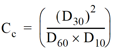 , equal to or greater than 1 and less than or equal to 3
The gradation in Table 4 - 10: Bioretention Soil Mix Aggregate Component Gradation is considered to be well graded.
Table 4 - 10: Bioretention Soil Mix Aggregate Component Gradation
Compost used as a component of the default bioretention soil mix (BSM) in bioretention facilities shall meet the specifications in A900 - Compost.
11.2.5.5.2 Custom Bioretention Soil Media
Projects which prefer to create a custom Bioretention Soil Mix rather than using the default requirements above must demonstrate compliance with the following criteria using the specified test method:
CEC ≥ 5 meq/100 grams of dry soil; USEPA 9081
5 - 8 percent organic matter content before and after the saturated hydraulic conductivity test; ASTM D2974(Standard Test Method for Moisture, Ash, and Organic Matter of Peat and Other Organic Soils)
2-5 percent fines passing the 200 sieve; TMECC 04.11-A
Measured (Initial) saturated hydraulic conductivity of less than 12 inches per hour; ASTM D 2434 (Standard Test Method for Permeability of Granular Soils (Constant Head)) at 85% compaction per ASTM D 1557 (Standard Test Methods for Laboratory Compaction Characteristics of Soil Using Modified Effort). Also, use Appendix V-B, Recommended Procedures for ASTM D 2434 When Measuring Hydraulic Conductivity for Bioretention Soil Mixes.
Design (long-term) saturated hydraulic conductivity of more than 1 inch per hour.
Note: Design saturated hydraulic conductivity is determined by applying the appropriate infiltration correction factors as shown in Table 4 - 47: Measured Hydraulic Saturated Conductivity Rate Reduction Factors in Appendix A - Appendix A Determining the Design Infiltration Rate.
If compost is used in creating the custom mix, it must meet all of the specifications listed above for the Default Bioretention Mix, except for the gradation specification. An alternate gradation may be proposed. The applicant is required to submit the alternate gradation specification which shall include similar particle sizes.
Do not use filter fabric between the subgrade and the Bioretention Soil Media.
Only install underdrains in bioretention areas if:
Located near sensitive infrastructure where flooding is likely
The facility if used for treating stormwater discharge from gas stations or other pollutant hotspots.
Where infiltration is not permitted due to site suitability criteria.
A bioretention facility with elevated underdrain may be used to satisfy Minimum Requirement 5 - Onsite Stormwater Management – List #2 provided the following criteria are met (though an underdrain is not required):
The measured initial Ksat of the underlying native soils is between 0.3 and 0.6 inches.
The invert of the underdrain shall be elevated 6” above the bottom of the aggregate bedding layer.
The distance between the bottom of the bioretention soil mix and the crown of the underdrain pipe shall be greater than 6” but less than 12”.
The aggregate bedding layer must run the full length and full width of the bottom of the bioretention facility.
A low permeability liner must not be present.
The underdrain pipe shall meet the following criteria:
Underdrain pipe diameter will depend on hydraulic capacity required, 4-inch minimum. A minimum 6-inch pipe is required for installations to be maintained by the City of Tacoma.
Underdrains shall be slotted, thick-walled plastic pipe. The slot opening should be smaller than the smallest aggregate gradation for the gravel filter bed (see underdrain filter bed below) to prevent migration of material into the underdrain pipe. This configuration allows for pressurized water cleaning and root cutting if necessary. Perforated PVC or flexible slotted HDPE pipe cannot be cleaned with pressurized water or root cutting equipment, are less durable and are not recommended. Wrapping the underdrain pipe in filter fabric increases chances of clogging and is not recommended.
Slotted subsurface PVC pipe per ASTM D1785 SCH 40.
Slots shall be cut perpendicular to the long axis of the pipe and be 0.04 to 0.069 inches by 1 inch long and be spaced 0.25 inches apart (spaced longitudinally). Slots should be arranged in four rows spaced on 45-degree centers and cover ½ of the circumference of the pipe.
Underdrains shall be sloped a minimum of 0.5 percent unless otherwise specified by the design engineer.
Provide a 6-inch rigid non-perforated observation pipe or other maintenance access every 250 to 300 feet to provide a clean-out port, as well as an observation well to monitor dewatering rates. Ensure access is placed so that it can be found with full vegetation growth.
Place underdrain on a bed of mineral aggregate with a minimum thickness of 6 inches and cover with 6” of mineral aggregate to provide a 1-foot minimum depth around the top and sides of the slotted pipe. The following table provides the gradation for the mineral aggregate. All filter media shall be double washed to ensure removal of fines.
Underdrains connected directly to a stormwater conveyance system structure shall be non-slotted for at least 2 feet from the structure interface.
Check dams are necessary for reducing flow velocity and potential erosion, as well as increasing detention time and infiltration capability on sloped sites. Typical materials include concrete, wood, rock, compacted dense soil covered with vegetation, and vegetated hedge rows. Design depends on flow control goals, local regulations for structures within road right-of-ways and aesthetics. Optimum spacing is determined by flow control benefit (modeling) in relation to cost consideration. See the Low Impact Development Technical Guidance Manual for Puget Sound for figures of typical check dams.
11.2.5.9 Hydraulic Restriction Layer
Adjacent roads, foundations or other infrastructure may require that infiltration pathways are restricted to prevent excessive hydrologic loading. Two types of restricting layers can be incorporated into bioretention designs.
Clay (bentonite) liners are low permeability liners. Where clay liners are used, underdrain systems are required. See A100 - Liners for guidelines.
Geomembrane liners completely block infiltration. They may line the entire facility or may be used to line sidewalls to restrict lateral flows. Where geomembrane liners are used to line the entire facility underdrain systems are necessary. See A100 - Liners for additional guidelines.
Submit a planting plan showing the type (species), location and size of each plant.
Plants must be tolerant of summer drought, ponding fluctuation, and saturated soil conditions.
Locate slotted pipe at least 5 feet from tree roots and other utilities.
Bioretention cells have three planting zones. Zone 1 is bottom area of the bioretention cell, which is frequently wet during the rainy season. Zone 2 includes the side slopes, which occasionally become wet during rain events. Zone 3 includes the area around the perimeter of the bioretention cell, starting above the top surface of ponding elevation, which has drier soil.
See A1000 - Vegetation for plants appropriate for bioretention facilities. For bioretention facilities that will be publically maintained, plants must be chosen from the list and approved by Environmental Services/Site Development Group in accordance with Joint Administrative Policy and Procedure Directive No. 2021-02-001. Additional information on planting zones and appropriate plants for each zone can be obtained through “Low Impact Development: Technical Guidance Manual for Puget Sound.”
In general, the following guidelines should be used when considering which plants to use:
At least 50% (by quantity) should be evergreen plants. Leaf fall can reduce the function of the facility.
Do not leave large areas of the soil unplanted/uncovered. Exposed soil can cause erosion and reduce the function of the facility. Plant types can be overlapped (tree canopy can overlap shrubs and groundcover) to reduce the area of exposed soil.
Provide a variety of plant types with various rooting structures. Plant variety encourages good soil health. Typical plant types used in bioretention construction include:
Emergents: Rushes, grasses, and sedges have shallow, fibrous roots that remain close to the soil surface. Planting solely with shallow rooted plants can cause thick root mats to form decreasing the infiltrative ability of the soil.
Woody shrubs and trees: Woody shrubs and trees have a mixture of shallow fibrous roots and deeper structural roots that can penetrate deeper into the soil and increase soil porosity over time.
Groundcover: Groundcover tends to form dense masses of vegetation low to the ground surface. Low, dense vegetation can be effective at consolidating soil in areas otherwise prone to erosion such as the side slopes of the facility (Zone 2).
Herbaceous perennials: Herbaceous perennials do not have woody plant parts and the above ground growth typically dies back in the winter.
Roots must not damage underground infrastructure.
Consider adjacent plant communities and avoid potential invasive species.
Consider aesthetics, bioretention facilities should blend into surrounding landscapes.
Irrigation may be required until plants are fully established and in the summer months.
Bioretention facilities should be designed with a mulch layer. Properly selected mulch material reduces weed establishment, regulates soil temperatures and moisture, and adds organic matter to soil.
Mulch should be free of weed seeds, soil, roots, and other material that is not trunk or branch wood and bark. Mulch shall not include grass clippings, mineral aggregate or pure bark.
Medium compost in the bottom of the facility, placed a maximum of 3" deep. Compost shall conform to the WSDOT Standard Specification 9-14.5(8) - Compost using the medium compost gradation. Additionally, compost shall not include biosolids or manure.
Wood chip mulch composed of shredded or chipped hardwood or softwood on side slopes, above ponding elevation, depth 4 inches. Do not use wood chips that may have been contaminated by preservatives, such as construction debris.
A dense groundcover can be used as an alternative to mulch although mulch shall be required until the dense groundcover is established.
Where higher flow velocities are anticipated, aggregate mulch may be used. Aggregate mulch must be clean washed rock that is free of fines. 1" to 1 1/2" rounded decorative rock is recommended.
For facilities sized to meet Minimum Requirement 5 - Onsite Stormwater Management using the list approach:
The top of the ponded surface area below the overflow shall be at least 5% of the total surface area draining to it.
For facilities sized to meet the Low Impact Development Performance Standard.
Model the facility using the bioretention element within a Washington State Department of Ecology approved continuous simulation model, assuming a 15-minute timestep. Size the facility to meet the Low Impact Development Performance Standard. The surface pool drawdown time shall be 24 hours or less.
For facilities sized to meet Minimum Requirement 6 - Stormwater Treatment:
Model the facility using the bioretention element within a Washington State Department of Ecology approved continuous simulation model, assuming a 15-minute timestep. Size the facility to treat or infiltrate the water quality design volume which is 91% of the total runoff volume as predicted by an Ecology approved continuous simulation model. Alternatively, size the facility to treat 100% of the water quality design volume. The surface pool drawdown time shall be 24 hours or less.
For facilities sized to meet Minimum Requirement 7 - Flow Control:
Model the facility using the bioretention element within a Washington State Department of Ecology approved continuous simulation model, assuming a 15-minute timestep. Size then facility to meet the flow control requirements. The surface pool drawdown time shall be 24 hours or less.
11.2.7 General Construction Criteria
Do not install media or excavate bioretention facility during soil saturation periods.
Excavation and soil placement should be done from equipment operating adjacent to the facility or by conveyor – no heavy equipment should be operated in the facility.
If equipment must be operated within the facility, use lightweight, low ground pressure equipment and scarify the base at least 12" to reduce compaction upon completion.
Clogged soil and silt shall be removed during excavation to finished bottom grade prior to installing bioretention cell profile.
Scarify sides and bottom a minimum of 3 inches to roughen before BSM placement.
Ensure the bioretention facility is protected from erosion and sedimentation until all contributory areas are fully stabilized.
If sedimentation occurs within the bioretention facility, excavate the area as necessary in minimum 6-inch lifts to remove sediment.
Subgrade infiltration rates shall be field tested per Appendix A - Appendix A Determining the Design Infiltration Rate and compared to design rates. Failure to meet or exceed the design infiltration rate will require revised engineering design to verify achievement of treatment and flow control benefits that were estimated in the design.
Prior to placement of the BSM, the subgrade shall be inspected by a Washington State Licensed Professional Engineer or Washington State Professional Geologist to verify condition.
Do not mix or place soil if the BSM or subgrade is saturated.
Place the BSM in horizontal layers not to exceed 12 inches per lift.
Compact the BSM to a relative compaction of 85% of modified maximum dry density. Compaction can be achieved by boot packing and applying 0.2 inches of water per 1 inch of BSM depth. Water for settling shall be sprayed or sprinkled.
Do not use bioretention facilities as temporary sediment control facilities. Construction of the bioretention area should not begin until contributing areas are stabilized. Inlets should be blocked until BSM has been placed and bioretention facility has been planted. All inlet protection shall be in place before inlets are unblocked.
11.2.8 Verification Testing
If using the default bioretention soil media, laboratory analysis for saturated hydraulic conductivity of the bioretention soil media is not required. The applicant shall provide verification of the mineral aggregate gradation, compliance with the compost specifications, and the mix ratio before soil placement.
If using a custom bioretention soil media, verification of compliance with the minimum design criteria cited above for such custom mixes must be provided. This will require laboratory testing of the material that will be used in the installation. Testing shall be performed by a Seal of Testing Assurance, AASHTO, ASTM or other standards organization accredited laboratory with current and maintained certification. Samples for testing must be supplied from the BSM that will be placed in the bioretention areas.
If testing infiltration rates is necessary for post-construction verification, use the Pilot Infiltration Test (PIT) method or a double ring infiltrometer test. If using the PIT method, do not excavate Bioretention Soil Mix (conduct test at level of finished Bioretention Soil Mix elevation), use a maximum of 6 inch ponding depth and conduct test before plants are installed. Per Joint Administrative Policy and Procedure Directive No. 2021-02-001, Environmental Services/Site Development Group will determine the need for post construction verification on a case-by-case basis.